August 13-20, 2006
Trip Report
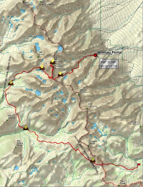
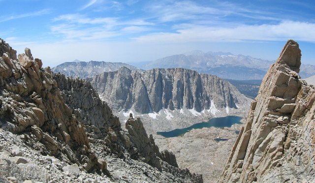
I climbed Mt. Whitney. I made it to the top, all 14,500 feet of it. I even spent a night on the summit. The temperature was below freezing, and the wind was 30 mph. And I was alone. Except for the weasels... But I'm getting ahead of myself. My trip began in the summer of 2005, when I approached two colleagues at work who were experienced hikers. Were they, I asked, interested in climbing Mt. Whitney? Their answer was an unequivocal "Yes", but there was just one problem. Mt. Whitney is so popular that one must apply in February for a permit in the summer. Even then, applications are entered into a lottery. Not all applicants actually get a permit. Since this was June, we could only plan for the following year. So plan we did. There are four basic strategies to choose from when climbing Mt. Whitney: two from the east and two from the west. First, the east. The closest you can approach Whitney by car is Whitney Portal, elevation 8,000 ft., on the east side. From there, the hike is 10.7 miles and another 6,500 ft. to the top, at which point you turn around and come back down again. This is the most popular, since it requires the least vacation time and no gear besides boots and a daypack. There are a couple of drawbacks, however. The first is that, because of the popularity, this route is by far the most crowded. The other has to do with altitude sickness. The climb isn't just from 8,000 ft. The closest town in the Owens valley is Lone Pine, about 13 miles away, but also 4,500 ft. lower in elevation. A drive to Whitney Portal followed by a hike to the top means an elevation change of 11,000 ft. in one day. And for those who start early from LA or San Diego and drive straight there, the change is a whopping 14,500 feet. Day hikers - I call them "commando hikers" - arrive at the top with headaches. Some arrive vomiting. In rare cases, they experience cerebral or pulmonary edema, which can be life threatening. Finally, apart from the crowds and getting sick, the physical demands of such a climb and a 21 mile hike in one day are extreme. The second strategy follows the same route, but takes time to allow acclimatization to avoid or substantially reduce any altitude sickness. Hikers simply camp on the trail one or two nights on the way up, and another one or two nights on their way back down. The climb is made much easier by breaking it down into shorter segments. There are two possible camping spots on the way up. Outpost camp, at 10,000 ft., is a four mile hike from Whitney Portal. Another two miles up the trail brings you to Trail Camp at 12,000 ft. From there it's another 4.7 miles and 2,500 ft. to the summit. This approach uses more vacation time. Not a big problem. It also requires a complement of camping gear. Again, not a problem for those who already have it. The gear, plus the food for the extra time, add weight, which make the climbing harder, but since there's less climbing in a day, there's a net gain. The main problem with this route is this. The trail goes up a narrow canyon, making it hard to stray very far from the beaten path - and the crowds. By the time the terrain widens out, you are above the timber line (no trees, no privacy) and the surrounding ground is solid granite (you can't dig holes anyway). Hikers are required to pack out their poop, and are issued special little bags, called "wag bags", for the purpose. Yuck. In fact, there are solar composting toilets at both Outpost and Trail camps. However, these fill up fairly quickly and are only emptied once a year. Consequently, they close without notice. During my trip, which was only one month into the season, the toilet at Trail Camp was still open, but the one at Outpost was already closed. Despite these drawbacks, there are still enough people to turn Outpost and Trail Camps into little tent cities. Fortunately, there is a better way: from the west. The lottery actually applies only to the Whitney Portal trailhead, the closest to Mt. Whitney itself. There are 150 day hikers and 50 multi-day hikers allowed each day. However, there are other trailheads to the north and south. These routes begin on the eastern escarpment of the Sierras, but then circle around and finally approach Mt. Whitney from the west. Although quotas also exist for these, there are issued on a first come, first served basis as opposed to a lottery. An early application virtually assures approval. And if you choose one of the distant western trailheads (Cedar Grove, Lodgepole or Mineral King), there are no quotas at all. Lodgepole is situated 82 trail miles west of Whitney Portal, on the western side of the Sierras. Two weeks hiking will cover that distance. The High Sierra Trail, as it's called, takes you across several ranges of mountains to the Kern River Valley. There you turn north to follow the river, which offers great fishing, waterfalls, and a Shangri La for weary hikers: natural hot springs. At the northern end of the valley, you turn east again, climbing up to Crabtree Meadow, Guitar Lake and finally Whitney Summit. After that you continue east and exit via Whitney Portal. And over all this territory, there are no roads. It's all National Park and Wilderness. This is a dream trek, a once-in-a-lifetime experience. The two main problems are vacation time and arranging a ride from the exit point. Because there are no roads between the start and end points, all ground transport must take a long detour all the way around the south end of the Sierras, then turn west and later north toward Bakersfield or Fresno, before finally heading east towards your starting point on the western side of the Sierras. It's a couple of hundred miles. You either need a lot of money for a shuttle - if you can arrange one - or go in two cars. Park one at Whitney Portal and take the other one to Lodgepole. At the end, everybody drives back to Lodgepole to the other car, and then go the rest of the way home in two cars. My hiking friends and I originally intended such a trip, starting either at Lodgepole, or at Mineral King. The latter route meets up with the High Sierra Trail at the Kern River. We hadn't worked out the details of the return, and were researching public transportation as a back up to an unresolved two-car plan. Public transportation turned out to be problematic, because of the aforementioned long detour. Technically, it's possible, but involves three different bus systems, and an entire day, to get only as far as Bakersfield. Because of these uncertainties, we also took out insurance in the form of a permit for one of the southern trailheads. It's a good thing we did, because both of my intended partners were forced to drop out on account of family commitments on the one hand and health problems on the other. I was on my own. And so we come to the fourth option. I planned to start at Horseshoe Meadow some 30 miles south of Mt. Whitney - on the east side - and go over Cottonwood Pass, working my way in a circular pattern around the group of peaks in the vicinity of Whitney before approaching the summit from the west. I would then join the western route described above at Crabtree Meadow and followed it past Guitar Lake to the top of Mt. Whitney. Then I would exit through Whitney Portal. By prior arrangement, a shuttle would be waiting there to take me back to my starting point. Planned Route
Planned Route (3D)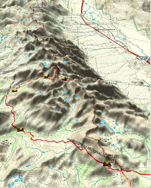
Trip LogSaturday, 8/12/06
I got away from San Leandro at 9:45 am. I took highway 120 through Yosemite National Park, crossing the Sierras at Tioga Pass, elevation 9943 ft. The park charges you $20 to enter, even if you are just passing through. The alternative is Sonora Pass on highway 108 further north, which is steeper and narrower and about 20 miles farther. A seven hour drive brought me to the Lone Pine Ranger Station, 333 miles from home, where I picked up my permit. Although my reservation had been approved and paid for months earlier, I still had to pick it up in person. At that time I was issued the obligatory wag bag, which is perhaps why they want you to stop there before you go in. I had some time to spare, so I stopped at a local coffee shop for a sandwich and then topped up with gas before continuing another 22 miles to the trailhead. The road to Horseshoe Meadow starts as a straight and level road at 3,500 ft in Owens Valley, but soon begins climbing a series of switchbacks up the eastern escarpment of the mountains until it brings you to the trailhead at an altitude of 10,000 feet. My strategy was to spend the first night at this trailhead so as to begin acclimating as soon as possible. When I arrived, it was evident that many other people had exactly the same idea. The trailhead was flowering with tents. My only difference was that I would spend the first night in my camper van, not my tent. I parked close to the trailhead, then stepped out and looked around. Trail: check. Bear boxes: check. Pit toilet: check. That was it. At home, I had more or less thrown all my gear, unpacked, into the van. Now I took the time to organize and pack it properly. Also, anticipating altitude related insomnia, I took a Melatonin before turning in. Despite the pill, I had trouble sleeping. Moreover, I developed a strong headache from the 10,000 ft altitude. At 3:30 am I got out of bed and performed the major excavation needed to reach the ibuprofen: in the first aid kit, in a gallon ziplock, in a side pocket of my pack, under the bed. I had to start by removing everything on top of the bed so I could retract the bed to access the pack, which was wedged between the two seats on either side of the van that formed the bed. I downed three pills. Although they eventually reduced the severity of the headache to a tolerable level, I also experienced some gastric discomfort and nausea - doubtless due to the altitude, since I had never experienced this side effect before. Sunday 8/13/06: Horseshoe Meadow to Chicken Spring Lake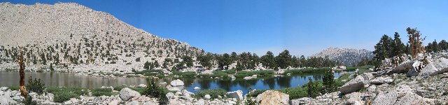
Chicken Spring Lake Start: Horseshoe Meadow Trailhead, elev 9870 ft. End: Chicken Spring Lake, elev 11,250 ft. Net elev: 1380 ft; Ascending elev: 1500 ft; Descending elev: 120 ft; Gross elev: 1620 ft Distance: 5 miles; Time: 4 hrs 30 minutes Water utilization: 16 oz = 3.2 oz/mile = 40 mpg Pack weight: 55 lbs The alarm went off at 6:00 am. I'd barely slept, and kept pressing the snooze button until 8:00. In the meantime, it was cold. My extra layers were buried even deeper than the ibuprofen. I turned on the van's propane heater and, between snooze alarms, snagged some extra sleep in a fair degree of comfort. I took a sponge bath, made breakfast and availed myself of the van's toilet, the last for the next week. Then I weighed my gear (50 lbs, plus 5 lbs of water) and finally hit the trail a few minutes after 10:00 am. A late start, but I was only planning to go 5 miles today. After an hour of hiking over the level meadow and adjacent forest, I came to a stream, where I encountered a woman who appeared to be in her early 70s, taking a break on the other side. It looked like a good spot to sit for a minute, which I did. She introduced herself as Patty, from Arkansas. This was her 12th trip to Whitney. The previous year she hadn't made it all the way to the top, and was not certain she'd make it this year. She was planning to take the same route as me, but was allowing 14 days to my seven. She was carrying the same map she had used on each trip, on which she had made notes each year as appropriate, regarding such things as distances, travel times and water sources. She was a mine of information. The trail would begin climbing from here, she told me, and there were 39 switchbacks leading up to Cottonwood Pass. She also told me the tale of Dr. William Penn Tuttle Jr., who died climbing in 1946 at the age of 27. His body was not discovered for a few days, by which time it was decomposing. Burials in National Parks are not permitted, so the rangers, who at the time had telephone access to the outside world (today they use radios) contacted headquarters in Washington DC and received special dispensation for a park burial. A team in Washington similarly had to contact the family and get permission from them. And so it was arranged. At that altitude, the topsoil is very shallow. They had to use dynamite to blast into the granite. Even then, they only managed to excavate to a depth of three feet. Thus it came to be that William Tuttle was buried on a spur of land overlooking an idyllic meadow in a scenic canyon in the high Sierras. And she told me exactly how to find the grave. I moved on after an hour of talking. The rangers, she told me, nicknamed her "Chatty Patty". Indeed. She even mentioned one by name: Erica. I reached the pass around 2:00 pm. A couple of hikers were resting there. I noticed the woman was wearing a ranger uniform. I learned later the man was her husband. As we were speaking, I spotted her name tag: Erica. "You have an old friend coming up the pass," I said. "Who's that," she asked. "Chatty Patty," I said. They looked at each other and laughed. By 2:30 pm I had crossed over Cottonwood Pass and arrived at the stream draining Chicken Spring Lake. In another 10 minutes, I was at the lake itself. There were two large groups - some members already there, others still trickling in - that I would be meeting on the trail for the next week. One was a group of 14 women in an organized "Gourmet Trek" that featured chef-prepared meals with wine. The other was a group of 18 boy scouts, a number that exceeded the legal limit by three. Plus there was the usual complement of singles, pairs and triples one would expect to find on the trail. Chicken Spring Lake was fast becoming another tent city. I located a shaded campsite and dropped my pack. I calculated my water consumption from trailhead to campsite: 16 oz. I had schlepped an extra 2 quarts - 4 lbs - all the way up the mountain for nothing. It was time for tea. But, handicapped by 11,500 ft altitude and a gentle breeze, my CampingGaz stove couldn't boil a cup of water. I finally gave up & made tea with merely hot, as opposed to boiling, water. It was weak. No matter. The sugar, creamer, warm liquid and half strength tea were still refreshing and stimulating. I had a second cup. This time I used a conveniently sized rock as a windscreen. The water boiled, but the low boiling point at this altitude meant the results weren't much different. I went looking for Patty. I asked a passing hiker if he'd passed a 70-ish woman on his way up, and he told he'd seen her at the stream. I decided to wait. Sure enough, she appeared momentarily. She spotted me and began heading my way. She arrived, announced she was bushed, dropped her pack and sat down to rest. We chatted for another hour. Then she set off to find a campsite, noting that she had never seen Chicken Spring lake so crowded. I made dinner, then pitched the tent. I went to find a bathroom spot and encountered Patty again. She'd found a site up the hill, not far from the trail. We chatted some more. She told me she wasn't sure that she'd make it to the summit this year, as she was tired from climbing this far. We both agreed that the main thing was to have a good time and not be a hero. I gave her my business card and asked her to write me when she got back and let me know how things worked out. Then I went to do my business and returned to camp. By 8:00 pm I was organized and in the tent. The temperature inside was warm enough, at 60°, but by 10:00 pm it was down to 48°; I put on an extra layer. Several miles to the southwest - 10? 20? - a forest fire had been burning for a few days before I arrived. The prevailing wind was carrying the smoke over a wide area, including most of my intended itinerary. While I slept, my nose became congested, reducing the flow of air which was thin to begin with. I wasn't getting enough oxygen. I would repeatedly wake up short of breath and gasping for air. I would switch to breathing through my mouth, which quickly dried out the mucus membranes and parched my throat. I'd swallow some water and go back to sleep, only to wake up gasping for air again a short time later. I developed a headache again and took more Ibuprofen. I learned from other hikers a few days later that both the breathing difficulties and the headaches were happening to everyone. Monday 8/14/06: Chicken Spring Lake to Lower Rock Creek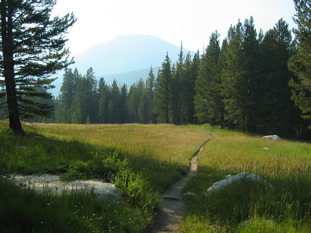
Approaching Lower Rock Creek: Mt. Guyot in the distance Start: Chicken Spring Lake, elev 11,250 ft. End: Lower Rock Creek, elev 9,600 ft. Net elev: -1650 ft; Ascending elev: 1090 ft; Descending elev: 2740 ft; Gross elev: 3830 ft Distance: 9.0 miles Time: 8 hrs 20 minutes Water utilization: 4.5 pints = 8 oz/mile, 16 mpg. Pack weight: 53 lbs This was my longest leg of the trip: 9 miles between Chicken Spring Lake and the next water source, Lower Rock Creek. I learned that there are in fact one or two water points along the way, depending on the season, but they're not on the map and you have to know exactly where they are, and I didn't. The trail away from the lake begins by climbing up to maybe 12,000 ft. before descending over the remaining miles all the way down to 9,500 ft. It seemed a shame to give up all that hard earned altitude only to have to climb it again, but that was the only way around the mountains to reach the western approach. The descent did compensate for the extra miles, however, so I arrived at Lower Rock Creek that evening tired, but in otherwise good condition. I left carrying my full complement of 5 pints of water, and arrived with 8 oz left. I had consumed 4 1/2 pints in 9 miles, or 8 oz per mile. I was getting 16 miles to the gallon. On my way I met still another group: a party of five whose gear was being hauled by an outfitter named Amy on horseback who led a team of mules. Amy and the gear went ahead. The hikers themselves followed with nothing but fanny packs. Ah, luxury in the wilderness. At Lower Rock Creek, I dropped pack at the first campsite I came to. Beautifully situated in a grove of pines between the creek and a meadow, it had water access, several tent spaces, and a fire ring. It turned out to be the only such site on that side of the creek. At high elevations, there are not only fewer trees, but the cycle of decomposition, soil renewal and new growth is much slower than it is lower down. Consequently, fires above a certain altitude are illegal, since the impact of wood burning, even of dead wood, would eventually denude the mountainsides of forestation. The precise altitude varies according to the location and the judgment of the governing authority. In 2006 in the Sequoia and Kings Canyon National Parks, no fires are permitted above 10,400 feet. The limit elsewhere in California is normally 9,000 ft. Where fires are allowed, heavy usage can still have a negative impact. The method the Forest Service uses to control this is to limit the number of fire rings, while forbidding fires outside of fire rings as well as the building of new ones. The number of fire rings has been steadily decreasing over the last 20 years, to the point where you can consider yourself lucky to find a vacant campsite containing one. Now packless, I continued down the trail toward the stream crossing. After a few hundred yards I encountered a park worker coming the other way. Her name was Sandy, and she was charged with locating and counting campsites in Sequoia National Park, both known and off trail, to compare the numbers and degree of impact with a similar survey about 30 years earlier. According to her, the wilderness was in better condition than it had been then, in the 70s. That didn't surprise me, because the wilderness ethic generally shared by hikers these days hadn't fully evolved by that time. I lamented the dearth of fire rings, commenting that they seemed to be disappearing left and right. She told me that had been going on for 20 years and suggested that I write the Parks Department. Then she gave me directions to a site across the creek that had a fire ring. It occurred to me later that her job probably included fire ring destruction. She also told me that the two large groups that shared Chicken Spring Lake with me the night before were encamped near the stream crossing, and that the result was another tent city. Having no desire to see that again, I turned around and returned to my campsite, gathering some firewood on the way. There was actually a lot of wood already there, but I had no intention of using it. It had been left there by clueless greenhorns: logs up to 10 feet long and 6 to 8 inches in diameter. It takes two people to carry logs like that, but that's not the main problem. It takes forever to get logs that large started. Then once they're going, it takes forever to put them out, if you can manage to do it at all. Inexperienced campers think they have to build a bonfire to enjoy themselves, and they don't take a hint from the size of the fire ring, which is only about two feet in diameter. So they pile up logs which extend outside the ring, start a little inferno going, toast their marshmallows or whatever it is that they do, and then go to bed with the logs still blazing away. That's a forest fire waiting to happen. The logs I gathered were 1 to 2 inches in diameter and 12 to 18 inches long. They're easy to start, easy to douse, and fully contained by the fire ring. If you want a cheery blaze, you just add more of them. When they burn down, they make a nice bed of coals perfect for cooking on. For a grate, I normally carry a cake cooling rack that I drop on the coals and level out with a stick. It makes a perfect surface for my pot, or even a fresh trout when I have one and want it grilled. I didn't have a grate, though. And I didn't have a trout. I didn't even have fishing tackle. Because of the elevation and the amount of climbing I had to do, I wanted to be as light as possible and had left those items behind, as well as my saw and fire starter paste. I also didn't need to cook anything, as I was planning to have cold cereal. So in the end, after all my carping about fire rings, I really didn't feel like going to all that trouble for nothing. Instead, I pitched the tent, took a few pictures and ate dinner. Then I called it a night. Inside the tent, I removed my boots and socks and examined my feet. I normally wear sock liners under my hiking socks, but had decided to try something different this trip. A friend of mine had told me that sock liners weren't really necessary, that thick wool hiking socks were enough by themselves. Since my boots were fairly snug with the liners, I decided to go without and see what happened. I should have stuck with what worked. Toward the end of the day, I had begun to feel something going on with my left heel. Now I could see the inside of the heel was red and chafed, though the skin had not yet separated and formed a blister. But I still had 26 hard miles ahead of me, and needed to make sure it didn't get any worse. I decided to address that problem in the morning and went to bed. I woke up around 2:00 am, shivering. The temperature was 40° in the tent, which should not have been a problem inside my sleeping bag. Then I remembered that I had replaced my 31 oz Thermarest with a Big Agnes air mattress to save 10 ounces of weight. The air mattress was 2 1/2 inches thick and was both softer and lighter than the Thermarest, but without insulation the convection currents inside the air tubes were sucking my body heat away and dumping it into the ground. As I contemplated how much colder Whitney summit was going to be, the phrase "sadder but wiser" crept into my mind. But I had more layers I could wear, and, considering that I would have brought the same clothing anyway had I not replaced the Thermarest, the air mattress wasn't such a bad trade off. Tuesday 8/15/06: Lower Rock Creek to Crabtree Meadow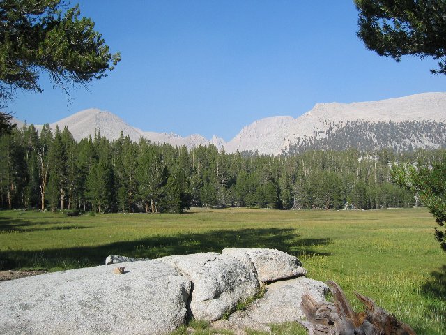
Crabtree Meadow Start: Lower Rock Creek, elev 9,600 ft. End: Crabtree Meadow, elev 10,400 ft. Net elev: 800 ft; Ascending elev: 1800 ft; Descending elev: 1000 ft; Gross elev: 2800 ft Distance: 5.6 miles Time: 6 hrs 50 minutes Water utilization: 2.5 pints = 7.1 oz/mile = 18 mpg Pack weight: 51 lbs I woke up at 6:00 am and was greeted with clear, 35° weather outside that warmed up soon enough. After breakfast, I laid open my first aid kit, bared my foot, and was considering various treatment options when I had a visitor. Lower Rock Creek is the site of one of a number of ranger stations. These are simple cabin shelters without flush toilets or running water, but they keep the weather out and do contain a wood stove. Rangers camp in them for up to three months at a time during the hiking season. They also serve as shelters for snow survey teams during the winter. My campsite was close to this one, and I hadn't been outside the tent for long when the resident ranger arrived and introduced herself. Laura Pilewski had come to remove the oversized logs from my campsite, but, finding me still there, began a conversation. Evidently she was sharing her cabin with Sandy and Sandy's partner, because she told me that she'd heard about my fire ring philosophy. I didn't really know what to think about my simple lament getting promoted all the way to a philosophy, and was worried that she was challenging me to defend it, but she kept on talking. In fact, she was almost apologetic. She said the motivation for the removal was to reduce the visual impact to the wilderness that fire rings leave. She went on to say that I could still build fires if I were far enough off trail, safely distant from trees and brush, cleared the ground of combustibles, put it out when I was done and removed or covered any visible residue. Regulations on the wilderness permits clearly say not to build fires outside of fire rings (and not to build rings where there are none). I didn't know whether she was telling me about an unstated loophole, or telling me how to build illegal fires without getting caught, but didn't ask. I appreciated her effort to improve my trips. Noticing my foot problem, she suggested using duct tape. I had been thinking in terms of band aids, or moleskin and adhesive tape, but duct tape sounded exactly like what I needed. It would protect from further chafing and, since it was thin, would add no pressure of its own. I retrieved my duct tape, cut a patch and applied it, then put my boot back on. I had packed one pair of sock liners, just in case, and was now wearing them. I would be wearing them for the rest of the trip. I thanked her for the tip and helped her carry off the big logs, each in a different direction. She asked me to say hello to her husband Rob in the next district, then bade me goodbye. I packed up and was on the trail before 10:00 am. By the time I crossed the creek, the tent city had disappeared. On the other side, I took a wrong turn and ended up in the stock camp, where Amy pointed me in the right direction again. I was soon overtaken by Sandy and her partner Amanda, the campsite surveyors. Rock Creek passes between, and about 3,000 feet below, two towering peaks: Mt. Guyot ("GHEE-oh") to the north, and Mt. Anna Mills to the south. After crossing Rock Creek, the switchbacked trail climbs steeply, rising 600 feet in the first half mile. Up until this point, the main view is of Mt. Anna Mills to the south, across the creek. Then it levels somewhat. From here on, Mt. Guyot (now to the west) dominates the landscape. Another half mile, gaining 200 feet, brings you to Guyot Creek. Here I caught up with Sandy and Amanda, who were having lunch. I decided this was a good place for mine also. Sandy and Amanda soon departed off trail in search of fire rings. I continued along the trail. From Guyot creek, the trail continues to rise, though not as steeply as from Rock Creek. It climbs 200 feet in the first half mile before the grade increases somewhat. Another half mile brings you to Guyot Pass, at 10,900 feet. I dropped my pack at first shady spot with a place to sit on the other side of the pass. Altogether, it was about a 1300 ft climb from Rock Creek. Although the temperature was about 70°, the sun was beating down and there was perhaps 10% shade on the trail. Climbing Guyot Pass was a sweat laden affair. I treated myself to a pint of Crystal Lite. Once over the pass, the trail drops 200 feet in 400 yards, bringing you to Guyot Flat, where it then more or less follows the contour for a couple of miles before dropping down into Crabtree Meadow. Guyot Flat, as is the trail from Guyot Creek to the pass, is sandy and sparsely wooded. This means, apart from the dearth of shade, that the distance to privacy is a good 300 yards. Guyot Flat boasts a view of the Kaweah range, across the Kern River Valley. Smoke from the fire many miles to the south was permeating the area, causing me to sniffle and sneeze. Also, my back was starting to hurt. I began stopping every 20 minutes or so to rest it. I arrived at Crabtree Meadow at 4:40 pm. Elev 10,400 ft. Water utilization: 5.6 miles, 2.5 pints, 18 MPG. I continued past the stock camp, and crossed Whitney Creek. The trail forked at this point, with the Pacific Crest Trail continuing North, and the Whitney trail branching East. I took the Whitney trail. The only nearby campsite this side of the creek was occupied. Level ground disappeared as I continued on the trail upstream. I turned around and headed uphill toward what looked like level ground at the top of a spur. Sure enough, I discovered a meadow there, with a clear spot for a tent on the far side. I was about to drop my pack, when I realized that the site was right next to a trail. Of course. This was the other branch from the fork, the PCT. But directly across the meadow was another suitable spot, this time the required distance from the trail. Setting up camp involved one minor mishap. As I dropped my pack, the weight shift caused me to lose my balance. Attempting to regain it, I spun and brought my left boot down hard - on the big toe of my right foot. I was already suffering the effects of a similar accident during my trip to Evolution Valley a month earlier. On that occasion, I dropped my 60+ pound pack and the bottom end of the frame crashed down on the big toe of my left foot. Now, a month later, the nail was dark and it looked like I was going to lose it. Oh, well. At least I was symmetrical again. I had camp set up by 6:00 pm. I had some tea first, followed by dinner. I went back down to the creek to replenish my water supply, and was in the tent by 7:25 pm for an early night. Wednesday 8/16/06: Crabtree Meadow to Guitar Lake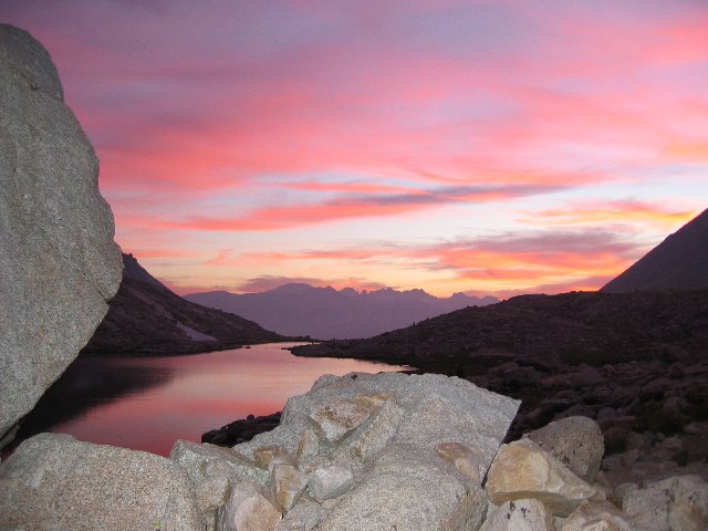
Sunset at Guitar Lake Start: Crabtree Meadow, elev 10,400 ft. End: Guitar Lake, elev 11,500 ft. Net elev: 1100 ft; Ascending elev: 1350 ft; Descending elev: 250ft; Gross elev: 1600 ft Distance: 3.7 miles Time: 6 hrs 40 minutes, including side trip Water utilization: 16 oz = 4.3 oz/mile = 30 mpg. Pack weight: 49 lbs Up at a quarter to eight. The temperature got down to 35-40° overnight. I was wearing extra layers this time, and so wasn't too cold. I took my time over breakfast and breaking camp. I was moving at 11:00. I stopped at the stream to top up my water and check out a lesser trail that crossed the stream. It led to more stock camps. I returned to the main trail. Around noon I was stopped to study my map when Ranger Rob Pilewski came down the trail, checking people's permits. He asked where I was headed and whether I had an exit permit for the Whitney Trail. I did, and said so. He didn't ask me to produce it. I passed on Laura's greeting, then asked if he could help me identify all of the surrounding peaks so I could more accurately interpret the map. He did. Then I asked him for directions to the gravesite. I already had directions, of course, but it wouldn't hurt to get confirmation, particularly with reference to landmarks he could point to as opposed to my depending on the map. He wanted to know how I had heard of the grave. Chatty Patty, I told him. "Who?", he asked. I said, "Woman, 70s, comes here every year, very social." "Oh", he said. "Yeah." He had to go, and so did I. I thanked him for his help and set off on search of the grave. I found it about 20 minutes later. It was as Patty described. I took pictures and kept going. At 1:15 pm I met 3 women hikers from Chico. Two nurses and a realtor. We took each others pictures, and exchanged information for a while. They told me everyone else was having the same breathing problems at night as I was having, on account of the smoke. Then we went our separate ways. They continued up along the main trail; I was ready for a lunch stop, so I took a detour to Rob's cabin, where I took pictures, found a comfortable log nearby, and ate. I shot a couple of pictures of a doe that wandered by. I got going again at 2:15. Not too much further up the trail, I got some shots of a pair of bucks. Two hours of hiking with occasional stops brought me to Timberline Lake, a wooded, picturesque site which, as its name implies, it as the timberline. A couple in bivy sacks were snoozing under a "No Camping" sign. After a rest, I kept going. In another 40 minutes there was nothing around me but granite. I arrived at Guitar Lake, elevation 11,500 feet, at 10 minutes to 6:00 pm. It was a tent city. Besides the numerous singles, pairs and trios, there was the Boy Scout group I'd last seen at Chicken Spring Lake on Sunday night. There appeared to be at least one other large group. I had to go all the way to the far, easternmost, side of the lake to find a vacant spot. I had camp set up by 6:30 pm. The pack-out-your-poop zone applies, strictly speaking, to the Whitney eastern drainage. That means the other side of the ridge from where I was. For practical purposes, however, it starts after Timberline Lake. There was diggable soil adjacent to Guitar lake, but it was occupied by tents and there were no trees. And beyond 100 yards or so from the shoreline, there was not even any soil. Just granite. I hoped I could hold it until Saturday. I made tea and dinner, then moved into the tent, where I changed out of my day clothes and prepared for bed. That's when I discovered my trousers were destroyed. At the outset of this trip, they were five years old and had thin patch worn in the seat from sitting on rocks. Now that thin patch had been transformed into two long rips, totaling about 24 inches between them. Not only was my butt exposed, the more I moved in them the worse the damage would become. My only backup was my fleece sweat bottoms that I slept in. I didn't especially want to hike in those. They'd look funny, they wouldn't stand up very long to granite, and they didn't have a fly. I brought out my sewing kit and spent the next couple of hours fixing up the tears in my khaki hiking pants. I finished a little before 9:30 pm. As a precaution against altitude-induced sleeplessness, I took a 25 mg Benadryl. It worked like a charm. I had trouble neither sleeping, nor waking afterwards. Thursday 8/17/06: Guitar Lake to Whitney Summit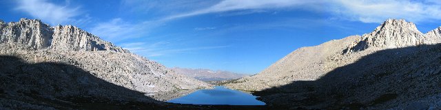
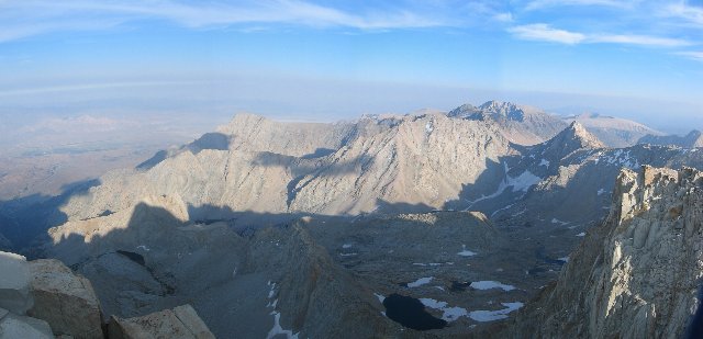
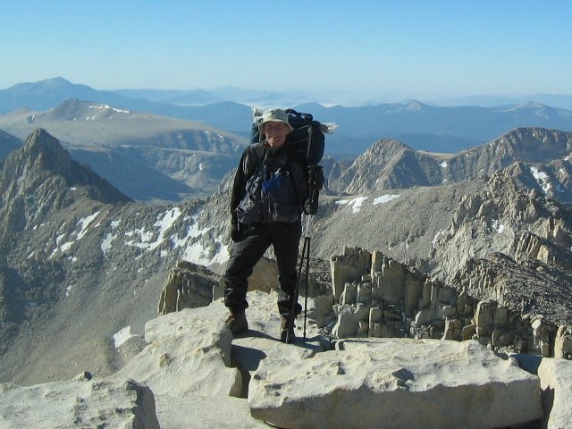
Leaving Guitar Lake Start: Guitar Lake, elev 11,500 ft. End: Whitney Summit, elev 14,500 ft. Net elev: 3000 ft; Ascending elev: 3250 ft; Descending elev: 250 ft; Gross elev: 3500ft Distance: 5.0 miles Time: 7 hrs 10 minutes Water utilization: 1 pint = 3.2 oz per mile = 40 mpg. Pack weight: 47 lbs I was woken at 4:20 am by the sounds of the first group of hikers passing my tent. I would learn later that this was the vanguard of the group of 14 women, who spent the night not at Guitar Lake, but at Crabtree Meadow, from which they had set out at 3:00 am with day packs. I went back to sleep. I woke up for good about an hour later, a little before 5:30 am. It was 50° in the tent, 40° outside. I was breakfasted, packed and on the trail by 8:00 am. The climb from Guitar Lake goes up the western side of Whitney Ridge, meaning that it is quite late before direct sunlight hits the trail. It was 9:27 am when I felt the first rays of the sun. The temperature was 43°. I was wearing a T-shirt under a long sleeved flannel shirt, which was ideal for the temperature considering the level of exertion imposed by the climb. In the 5 miles from Guitar Lake to Whitney Summit, one gains 3,000 feet of elevation. It was at this time that I encountered one of the Crabtree-to-Whitney-to-Crabtree day hikers - the party that woke me at 4:20 am, on her way back from the summit. Her round trip was 17.4 miles plus 4,000 feet up and another 4,000 feet back down. I'd done more than that at Half Dome in Yosemite two years before, but that was 6,000 feet lower than Whitney. I was happy with my itinerary. I stopped a little after 10:00 am for the first of two lunch breaks. I didn't want to run out of fuel and bonk before I got there. At 11:00 am I could see the peaks of the Kaweah Range, on the far side of the Kern River Valley, over the top of Mt. Hitchcock. My back began troubling me again. I began to stop for rest more often. 11:18 am. At 13,000 feet, I was halfway: half the distance, and half the climb, from Guitar Lake. 11:33 am. Another back rest stop. Estimated altitude 13,200 feet; my respiration was 30 per minute, pulse 96. By way of comparison, at sea level, at rest, my RPM is 12 with a pulse rate of 60. At sea level, when I'm running a road race, my RPM is 30 with a pulse rate of 160. At high altitude your pulse rate doesn't get as high. The limiting factor is the gas exchange rate in the lungs. When the air is thin, there's no point in pumping the blood faster because you can't get any more oxygen that way. I reached Eagles' Rest at 11:44 am. The temperature was 48°. Here the trail divides: to the east it climbs to Trail Crest at 13,600 feet. The north fork goes to Whitney summit. I rested a few minutes, then headed for the summit. Here the trail actually descends, forcing you to give up some of that hard won altitude, before resuming its climb. The total climb to the summit from Guitar Lake is thus a couple of hundred feet more than 3,000. I kept going, stopping frequently to rest my back.
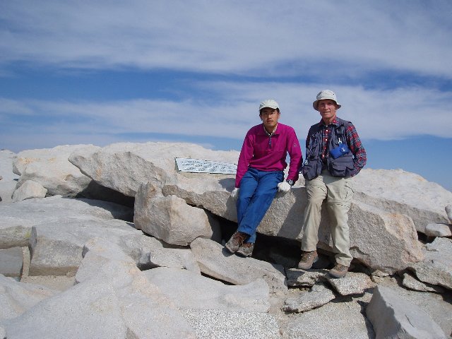
Mt. Hitchcock as seen from the ridge crest trail between Trail Crest and the summit. One descending hiker pointed out the summit for me. I'd been seeing it for some time without realizing what it was. It was a round, dome-like structure with a sandpaper-like surface. It didn't look very far away. Then he told me to follow the skyline from right to left. "See that little rectangle?" he asked. "That's the hut." I saw what he meant, and my jaw dropped. Depth perception fails at a distance of about 200 feet. Beyond that, we depend on objects of known scale for comparison. But when you don't know the scale of what you're looking at, and there's nothing of known scale to compare it to, there's no way of judging how far it is. I knew from reading a Whitney trip report that the hut was big enough to hold several people. As it turned out, it was the size of a bus, though only one third of it was accessible. But from here it looked the size of an ant on the floor. The specks that looked like grains of sand on paper were rocks the size of cars! The dome was enormous! It was over a mile away! As I made my way to the top, I saw daypacks coming down but no backpacks. Most people prefer to summit with minimal extra weight from a lower campsite, or even Whitney Portal. But, of course, if there were any campers at the top, I wouldn't be seeing any backpacks coming down, not at this time of day. They'd be staying the night. I began to wonder how many overnighters there might be. This was a concern because I'd been told of "a couple" of tent shelters on top, walls of piled rock high enough to shield a tent from the wind. A shelter was big enough for one tent. But if they were all taken... No matter, I thought. I'll find out when I arrive. About that time I noticed a pair of hikers coming up the trail behind me. The one in front appeared to have a large pack. It looked big enough to be a backpack. Campers, I thought. And what if there's only one more shelter? I decided I'd better get there first, and increased my speed to maximum. 30 RPM. Breathing through my mouth. Quads just starting to burn. I was doing maybe 2 mph, carrying my 50 lb pack uphill at 14,000 feet, where there's only 57% of the oxygen at sea level. Any faster and I'd hit the wall. I once stopped to rest, but when the hikers came into view after a minute, got up and resumed flank speed. I covered the last mile in 31 minutes. I made it the top ahead of them. At 3:11 pm, I dropped my pack at the first tent shelter I spotted, which was the one nearest the hut. Water utilization: 5 miles, 1 pint from Guitar Lake to Whitney Summit. 3.2 oz per mile. 40 mpg. I circled the hut to see whom I'd been racing. They arrived momentarily. It turned out to be a young couple from San Diego. They weren't camping. It was just a large daypack. She had altitude sickness: headache, fatigue, nausea. She took refuge in the hut, where she sat on the bench. There were three rooms altogether, but the other two were locked. He gave her Ibuprofen and half a sandwich; I brewed her a cup of tea. After a few minutes, she felt a little better and they started down. I can tell you, that sure took the wind out of my sails. After years of workouts and training, I could barely outpace a vomiting girl who wasn't racing anyway.
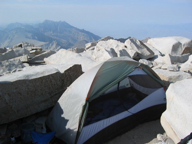
I added layers, since it was now getting cold. Then I set up camp, made tea, then dinner, brushed my teeth and stored the trash and food in my bear canister. Then I began to wait for sunset, at which time I would take pictures and go to bed.
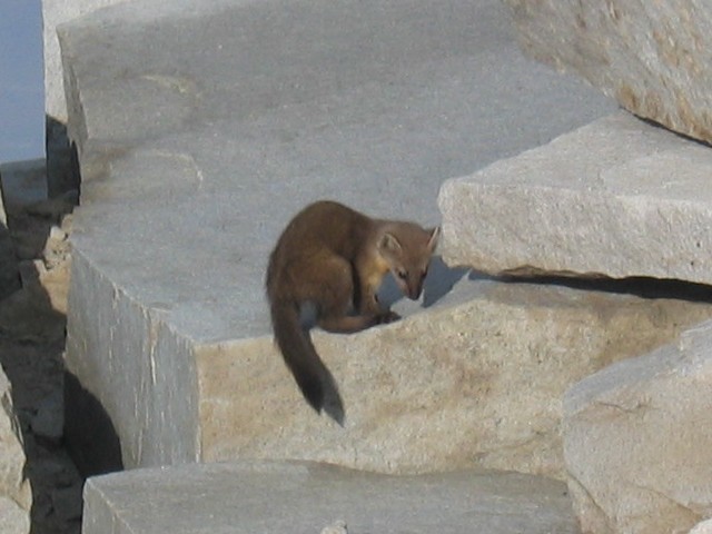
I stood up to explore the summit, at which point I saw a family of some kind of small, furry rodents approaching my position. As soon as they saw me, they changed direction and began skirting around me in a giant circle roughly following the edge of the summit. They were hard to identify. They didn't look like the marmots I had photographed earlier. They had some canine and some feline features. They looked like baby foxes with cats' tails, shorter noses, lanky bodies and round, Mickey Mouse ears. I followed them around the edge of the summit as they darted in and out of the holes between and under the rocks. They never gave me more than a second to snap a picture, and my camera took longer than that to autofocus. I managed to get a couple of distant shots in less than clear poses. As I wrote this, I heard sounds emanating from the hut. I was the only human on the summit. I imagined it was more of these critters, or the same ones, since I had first seen them in the vicinity of the hut. I determined later that they were American Martens, sometimes called Pine Martens. They are related to weasels, and are terminally cute.
I checked out the other tent shelters. There were a total of five, though one was probably only big enough for a bivy sack. By sunset it was 40°. I took pictures, then went inside the tent. The tears in my pants I had sewn up so painstakingly the night before had split open again the first time I sat down on a rock. Tonight I switched to plan B and fixed them with duct tape, inside and out. Again, I took a Benadryl. I had acclimated well over the last few days, and was experiencing none of the symptoms of altitude sickness, even right at the top. But I needed a good night's sleep, so why take chances?
Friday 8/18/06: Whitney Summit to Trail Camp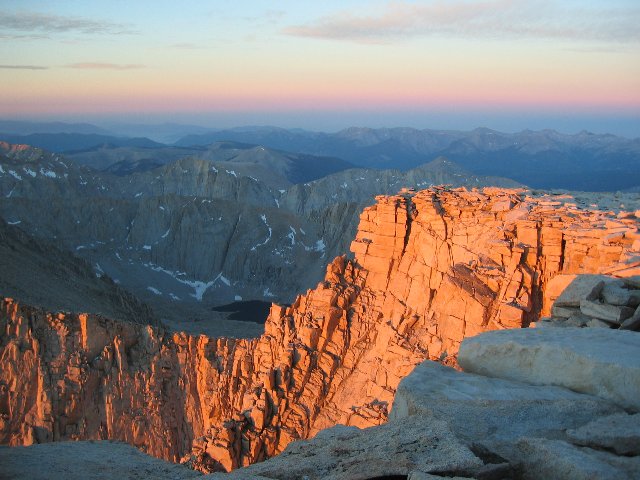
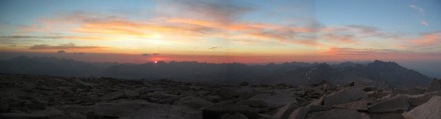
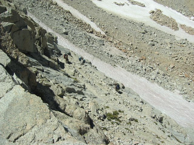
Dawn: Alpenglow on Mt. Whitney Start: Whitney Summit, elev 14,500 ft. End: Trail Camp, elev 12,000 ft. Net elev: -2500 ft; Ascending elev: 350 ft; Descending elev: 2850 ft; Gross elev: 3200 ft Distance: 4.7 miles Time: 5 hrs 45 minutes Water utilization: 20 oz = 4.25 oz/mile = 30 mpg. Pack weight: 45 lbs The tent was buffeted all night by high wind. I was woken by this noise on occasion, but other than that I slept fine. I arose at 5:30 am to catch the sunrise. I put on my Marmot rain suit over my clothes to act as a shell, and emerged from the tent to be greeted by the 30 mph wind that was now 30°. I was thankful for all of my layers, all the way down to my long johns. A party of four was already there, having left Trail Crest at 3:30 am and arriving at the summit at 5:00. We took each other's pictures as the sun rose, then they headed back. I made breakfast, packed my gear, and greeted more early arrivals on my way out. I took some more photos, and started back down at 9:15. I stopped a few times to chat with early hikers on their way up, finally making it to Eagle's Rest by noon. There I shed some layers, ate lunch, and rested with two other hikers who were likewise taking a lunch break. One had hiked the John Muir Trail all the way from Yosemite, over 200 miles. While we were shooting the breeze, we spotted a hiker coming up the trail from Guitar Lake. He was about my age. He was struggling. He would take one step, then pause, hanging by both hands from his hiking staff, for four breaths. Then he would take another step and stop for another four breaths. He repeated this procedure until he was level with us. He stopped for a while. He told us that his partner had gone on to the summit, but that he couldn't keep up. He was going to continue, not to the summit, but to Trail Crest, where he would wait for his friend. He expected no problem keeping up while descending the other side. He told us that he had climbed Whitney every year for the last 31 years, and that this was the first year that he failed to make the summit. Then he moved on, headed to Trail Crest, which is one, maybe two hundred feet higher than Eagle's rest. I followed not long after, passing him before he reached it. At Trail Crest, elevation 13,600 feet, I paused to admire the view in both directions: Mt. Hitchcock and Guitar lake to the west, and the Owens Valley to the east. Straight down, 1,600 feet below, was today's destination - Trail Camp - though it was still too far to see any detail such as people or tents. Between Trail Crest and Trail Camp lay 97 switchbacks. I passed the time on the way down by counting them. At switchback no. 74, counting from the top, was a spring. Water was simply flowing out of the granite mountainside and cascading down the slope, wetting the trail in several places. I topped up with water.
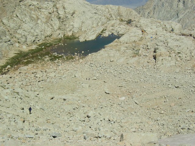
At 3:00 pm, I walked into Trail Camp, elevation 12,000 feet. Water utilization: 4.7 miles, 20 oz = 4.25 oz/mile = 30 mpg. The first order of business was to visit the toilet. High on the mountain there is only granite. There are no trees and no soil. There is, in other words, no place to dig a cat hole, and no privacy even if you could. My plan to hold it till Saturday wasn't holding up. It was all I could think of during my descent, and I had even begun to contemplate the hitherto unthinkable: dealing with a wag bag inside my tent. Fortunately, as it turned out, the solar composting toilet was still open, though possibly not for much longer. It had opened for the season one month earlier, and was now at 50% capacity. That was plenty for today, though. Blessed relief! Trail camp was a tent city next to a lake. It was quickly filling up. As usual, the Boy Scouts were ahead of me, but there were many parties besides them. I wandered around looking for a vacant space. As on the summit, a lot of sites were formalized with a rock wall to shield the tents from high wind. I found an empty one and dropped my pack. Before I could pitch the tent, a Korean woman sitting on a rock nearby started making conversation. Her husband was attempting the summit while she stayed behind. Now she thought he was late and was worried about him. She was sitting at a point where she could watch hikers as they descended the famous switchbacks, and also watch them pass on the trail nearby. Eventually, I began making camp and she moved further up the trail so as to spot him sooner. Camp made, I replenished my water supply from the lake. The lake was a small, shallow stagnant pool of melted snow adjacent to a stopover for hordes of hikers with unknowable sanitary practices. I made sure to treat it with iodine pills. Then I looked for the Korean woman to see if she had found her husband. Presumably she had: she was no longer to be found. Once back at the tent, I made dinner - cereal again, secured the food and went to bed at 6:00 pm. Once again, I took a Benadryl. Why change a winning routine? I spent time updating my log before going to sleep at 7:30. Saturday 8/19/06: Trail Camp to Whitney Portal, then home.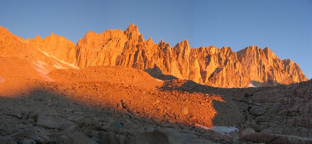
Sunrise at Trail Camp: Alpenglow on the Ridge Crest Start: Trail Camp, elev 12,000 ft. End: Whitney Portal, elev 8000 ft. Net elev: -4000 ft; Ascending elev: 200 ft; Descending elev: 4200 ft; Gross elev: 4400 ft Distance: 7.0 miles (including backtrack) Time: 4 hrs, 35 minutes Water utilization: 32 oz = 4.6 oz/mile = 28 mpg Pack weight: 43 lbs I rose at 5:00 am to get pictures of the alpenglow on the ridge at dawn. They were spectacular. It was 40°. I ate, packed and was on the trail before 8:00 am. It was 6 miles down the mountain to Whitney Portal. I had arranged to meet the shuttle driver at the store there at 1:00 pm. But I also wanted to leave time for a hamburger at the store, since I hadn't had any real, cooked meat for a week. So I was aiming to arrive by midday. Downhill. 40 minute miles. No problem. I stopped at a picturesque stream to top up my water and to take a picture. At 9:00 am I missed a turn without noticing it. I just became aware at some point that the granite I was walking on wasn't a trail any more. I started looking around for the real trail, and found it in short order. Sierra hiking trails are almost never 100% up or 100% down. There are always some down stretches on a climb, and some up stretches on a descent. Therefore, I thought nothing of the fact that I was now climbing. And climbing. Like when I was on my way to the summit, I had to descend a few hundred feet. And on my way down, I had to climb a few hundred up to Trail Crest. It was only when I got to the stream I had photographed half an hour before that I realized that I'd gotten turned around. I'd spent half an hour backtracking! And I'd spend another half an hour getting back to where I got turned around! I'd lost an hour! Now I was in a hurry. It began to look like I wouldn't have time for that hamburger. Damn! I poured on the speed. I went downhill with long strides and rarely stopped to rest. One effect of this was to jam my toes repeatedly into the end of my boots, turning a third toenail purple. My feet were beginning to look like a troll's. But the other effect of this vigorous workout was to pump up the euphoria I had already been feeling since reaching the summit into a positively manic state. Hikers on their way up would greet me with "How ya doin'?" "COULDN'T BE BETTER!!!" I screamed back as I bounded down the mountain.
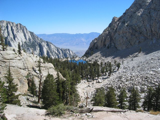
After a couple of hours of this, I calculated that I would get down with some time to spare for my hamburger, so I let up and returned to a normal pace. I arrived at 12:33 and paid, without blinking, more than I've ever paid in my life for a hamburger. I also bought a Mt. Whitney polo shirt, paying more than I've ever paid in my life for a polo shirt. Then I sat down in the first real chair I'd had in a week, and almost melted in comfort. I was nearly finished eating when my ride showed up. Norm and Jen Wilder were making extra money by shuttling hikers. The whole family was there: Norm, Jen and their two daughters. Since it was a Saturday and the car was going to Whitney Portal, they brought the kids for some fishing. Norm would stay with them while Jen drove me back to my van at the trailhead. They were patient while I finished my burger, and then Jen took me back to Horseshoe Meadow. I weighed my gear. I carried out 42 lbs, 13 less than I carried in. I'd also lost a pound myself. In the comfort and privacy of the camper van, I washed up, changed into fresh clothes, and drank a coke before driving off. I stopped in Lone Pine for gas and another T-shirt, then headed for home. I didn't feel like paying another $20 to drive through Yosemite at night, so I kept going North when I reached Lee Vining and went over Sonora Pass instead. Sonora Pass is a slower road, but one I find more interesting. After stopping for dinner in Sonora, I finally got back home at 12:30 in the morning. Weeks later, as I write this, I am still feeling the afterglow. I don't think it will ever go away entirely. |